Dambreak/Flood Modeling
Key capabilities
|
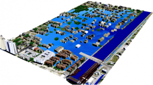
Flood simulation in 17th street of New Orleans due to Hurricane Katrina |
|
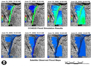
In June 2008, the Mississippi River in the Midwest USA experienced a high flood. More than 22 flooding zones were observed along the Mississippi River, resulting in at least 24 fatalities in 51 counties in 5 states (Illinois, Missouri, Wisconsin, Iowa, and Minnesota). In order to study the flood impact on agriculture in the flooded zones, the computational model, CCHE2D, was applied to simulate levee breaching and flood propagation in one reach of the Mississippi River near Canton City, Missouri. The computational results agreed with that observed from satellites very well. |
SIMULATION OF MIDWEST FLOOD 2008
|
|
SIMULATION OF FLOODING DUE TO 17THSTREET CANAL LEVEE BREACHING, NEW ORLEANS, DURING HURRICANE KATRINA CCHE2D flood model was applied to simulate flooding in the neighborhood immediately outside the breaching. A fine mesh was generated based on Lidar topography and satellite imagery. Storm surge boundary conditions (~10ft) were specified at the end of the Canal. The detailed flow field and flood wave propagation can be visualized. |
|
|
|
SIMULATION OF EARTH DAM BREAK USING LARGE-SCALE LABORATORY DATA |
| Coastal flood can be the result of storm surges and waves. It could also be caused by torrential rains and over-bank flooding of inland channels. In this situation, the flooding of a coastal zone is affected by the water from both sides. |
|
LEVEE CLOSURE SIMULATOR The CCHE2D levee closure simulator has been applied to the 17th Street Canal levee breaching case which was caused by Hurricane Katrina. The U.S. Army Corps of Engineers attempted to use large sandbags, 3,000- to 7,000-pound, with military and civilian helicopters to close the breaching. This levee closure simulator can simulate the closure process using sandbags or other materials. The computer can put "sandbags" into the water interactively and the stability of the bags can be evaluated by the simulation model. With more and more stable bags the flooding can be stopped. The hydrodynamics is simulated at the same time when the bags are "dropped" in the water. In this application, real flow conditions and real-sized sandbags were also used. |
|