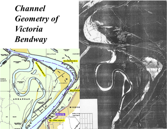
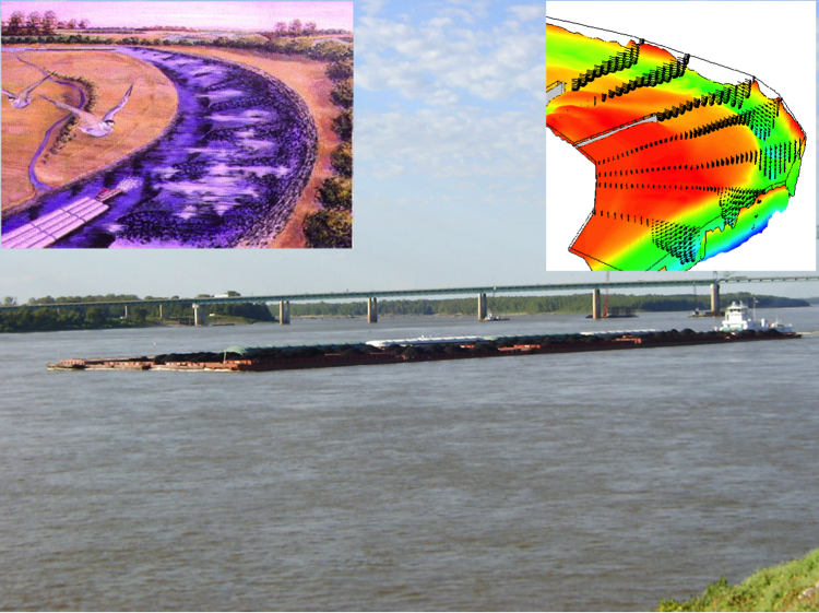
Evaluation of Bendway Wire Effectiveness in Mississippi River
Flow in curved channel bends is typically characterized by helical secondary currents which play an important role in redistributing the momentum of river flow in a cross-section, resulting in lateral sediment transport, bank erosion and channel migration. Secondary currents introduce difficulties for channel navigation because it tends to force barges toward the outer bank. Submerged weirs are engineering structures designed to improve navigability of bendways. They have been constructed along many bends of the Mississippi River for improving barge navigation through these bends. Because of the complexity of channel morphology and flow conditions, not all the installed SWs were effective as expected. It is necessary, therefore, to study the turbulent flow field around submerged weirs and the mechanisms affect on navigation.
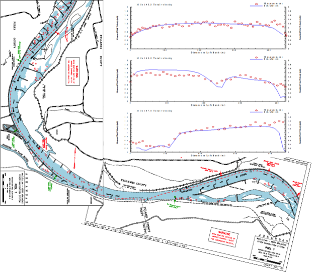
Arkansas River Navigation Channel Dike System Design
Channel navigation is an effective and economic means of transportation. Deeper waterways would allow more commodities transported with lower costs. The dike field in a navigation channel could be modified for creating a deeper navigation waterway. Numerical simulations using CCHE2D have been conducted for redesign of river training dike fields to deepen the navigation channel of the Arkansas River. Sediment transport and bed change were simulated with a variety of dike field and hydrologic parameters to achieve the design objectives.
|

|
|
|
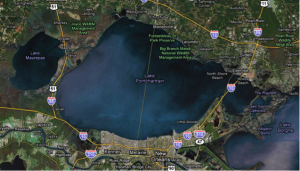
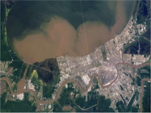
Environmental Impacts of Flood Release from Mississippi River to Lake Pontchartrain
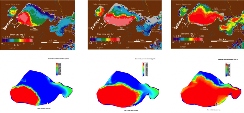
Large amount of sediments entered Lake Pontchartrain from the Mississippi River during large flood events. The fresh water changed the salinity balance. The high level of nutrients changed the aquatic environment and the suspended sediment would take a long time to deposit or move out of the Lake.
 Lake Ponchartrain |
 Sediment and nutrients discharged into lake |
 Algal bloom |
 Bonnet Carré Spillway |
Simulation of Suspended Sediment Plume due to Flood Release in 1997
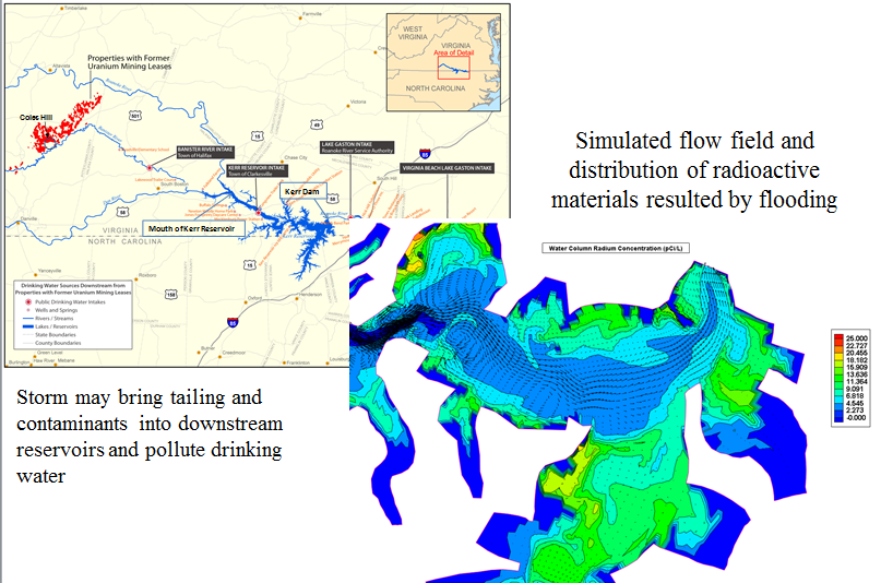
Potential Impacts of Radioactive Contamination on Drinking Water in Reservoirs
Drinking water supply reservoirs could be polluted by radioactive contaminants due to upstream mining. The mining and milling operations need tailing dams to store remaining radioactive materials during the extraction process. The location of the tailing dams is prone to extreme storm events. In case of failure, the stored radioactive contaminants would be released and flushed downstream. The potential impacts of tailing dam failure on the water quality at the water intake have been assessed for decision makers.
Evaluation of Impact of Hurricane Gustav on Mississippi-Louisiana Coast
Tropical cyclones such as hurricanes or typhoons often cause disastrous property damage and loss of life in coastal regions due to severe flooding, inundation, shoreline erosion, and barrier island/levee breaching. Numerical simulation of hydrodynamic processes of storm surges is an important tool for coastal disaster mitigation. CCHE2D-Coast has been applied to simulating waves and storm surges caused by Hurricane Gustav (2008) in the Southern Louisiana and Mississippi coast. Computed results for storm surges and wave parameters are in good agreement with the observations provided by NOAA’s gage stations. This model has been applied to simulate several other tropical storms such as Katrina (2005), Isaac (2012), Sandy (2012) which made landfall in the northern Gulf coast and the U.S. Atlantic coast.
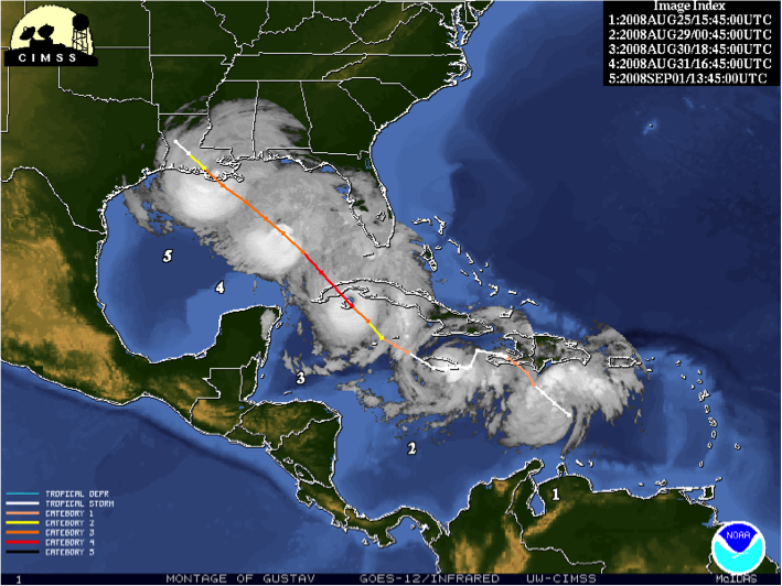
Left: Gustav’s track observed by NOAA
Comparison of Predicted Water Elevations with NOAA’s Gage Data
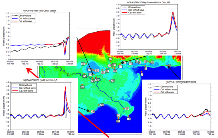 Comparisons of water elevation above NAVD88 at NOAA tide gauges during Gustav. Blue lines: computed water surface elevation without wave setup; Red: with wave setup; Block dots: NOAA’s observation data
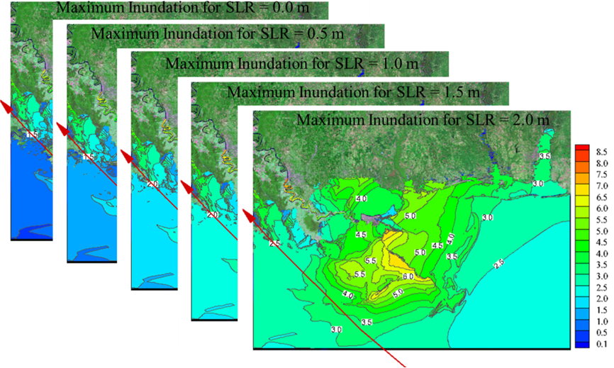 Computed maximum water elevation and inundation maps under various sea level rise (SLR) scenarios for impact assessment of hurricanes under the future conditions of SLR in the northern Gulf coast zone
Coastal and Estuarine Planning for Flood and Erosion Protection
This project is an application of the CCHE2D-Coast model to a coast zone near Touchien Estuary, Hsinchu, Taiwan. The model was applied to simulate hydrodynamic and morphodynamic processes in an estuarine area including rivers and coastal zones in responses to combined tides, waves, river flood, and winds. To identify the optimal plan for flood prevention and erosion protection, a number of engineering plans were evaluated by simulating long-term variations of water elevations, currents, and morphological changes under hypothetical multiple-year storm-monsoon events. Numerical results enable engineers to find the most desirable plan for protecting the estuarine area from flooding and erosions. The integrated modeling system provides a comprehensive assessment tool for coastal and estuarine planning and management in complex hydrological and geomorphologic conditions.
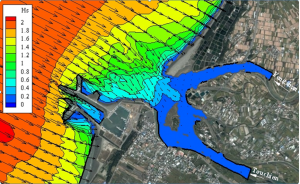 A snapshot of computed significant wave height in a typhoon in Touchien Estuary
 Computed water stages and flow velocity at a flood peak.
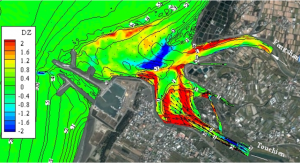 Computed bed changes after multiple typhoon events occurring between 2004 and 2006 in the estuary.